Ever since I first hiked the Pfeifferhorn shortly after moving to Utah, I've always had the Northwest Couloir in the back of my mind. With stable conditions and "supposedly" solid weather for the morning, Justin and I set out early to ski it. We rolled up to the White Pine Trailhead and were on the trail by around 4. The approach over into Red Pine and up to the lakes went really well and we made good time. After gaining the ridge near No Name Baldy we were able to get a few views of the surrounding Wasatch before the bad weather rolled in. We watched the clouds swallow the Pfeiff and move down to us just in time for the knife's edge traverse.
Views of Box Elder and Utah Lake
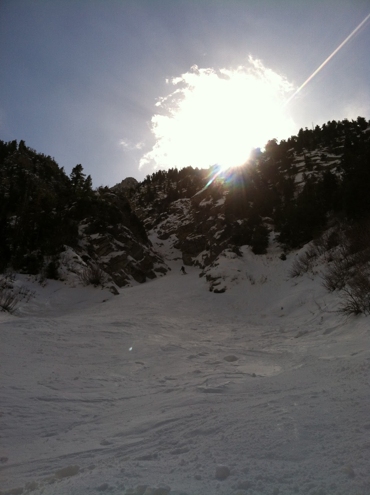
Approaching the knifes edge ridge as the clouds rolled in
Justin led the ridge with the one ice-ax we brought and kicked steps for me to follow. I felt a little bit exposed on the ridge without a self-arrest tool, but the snow was stable and none of the moves were difficult. The traverse was much more fun then scary. At the end of this traverse we reached the base of where the Pfeifferhorn jets out from the rock, earning it's nick-name "Little Matterhorn". The standard route goes up the southeast facing snowfields to the summit, but we found ourselves sinking into a lot of deep wind drifted snow and thought it would be safer to stay mostly on the ridge going up from the East. From the start of the knifes-edge ridge to the summit it had been mostly a complete whiteout and we weren't sure if it would be safe to drop the NW couloir with the really poor visibility, since neither of us had skied it before.
Justin leading the way
Weather clearing up on the Pfiefferhorn summit
Fortunately the weather cleared a few minutes after summiting and we were able to get a view of what we were skiing. We threw on our harnesses and got ready for the descent. On most years you can drop right from the summit and ski to the main rappel. However, there was about a 15 foot ice and rock gully about 50 feet down that couldn't be skied. This became a problem for us and our 30 m rope we brought. To get down I lowered Justin to below the gully, rappelled down as far as I could go and did some sketchy downclimbing to get through the gully. Not exactly what I wanted to be doing above a 50 degree chute into a cliff. From the bottom of the gully we enjoyed a few hundred feet of steep skiing in variable snow before inching up to the rap station. The anchors are almost directly about the drop-off on skiers right and can be a little scary to get to. There is another anchor about 40 feet above it on skiers left for those who don't feel comfortable approaching the main rap but not very necessary. Our 30 m rope worked perfectly for the current amount of snow and the rappel went smoothly. From the bottom of the cliff, the route raps around skiers right of some large cliffs and we enjoyed our turns in damp snow down the apron as more clouds rolled in. We skied by many of the awesome lines in Hogum Fork as we made plans for future link-ups. Opting for the exit out of Hogum Fork, we skied for as long as we could and then bushwhacked out for about an hour until we reached the road. The NW Couloir was definitely one of the craziest lines I'd ever skied and inspired me to get on some more technical routes in the future.
A big April snowstorm and little time to ski. With papers to write and finals to study for we didn't have very much time to go skiing, but still wanted to get some of the last powder of the season and get a little scare. We decided to go check out Holy Mole, a line running North off of Toledo Peak. After a quick skin up Toledo Bowl, we reached the start of Holy Toledo and continued up the ridge to the first obvious saddle. From here you ski some open trees straight down until you come across a choke that is the only way down through the cliff band. Luckily for us the cruxy steep section was filled in, but still required a committing quick turn to get through. There was a fixed line buried in the snow that can be used to get past this section. Most of the new snow had already slid off this choke so sluffing didn't play a big of a role as we were worried about. Before we started down I was telling Justin that the cliffs "aren't that big". I realized how wrong that was once we got through the choke and could see what we were skiing on top off. The run ends with a fun couloir that dumps you into Cardiff Fork. A quick skin up to Cardiff Pass brought us back over to LCC and we chose to exit through a little chutellete off of Cardiff ridge.
Crappy picture of the choke
Getting powder in the Couloir
Holy Mole Couloir, with the "not so big cliffs" on the left
The last month or so we've been falling behind in the blogging. Finals and crappy weather have put a damper on the skiing adventures and led to more desert climbing outings than ski touring. Here's what we've been up to the last month.
Perfect powder on God's Lawnmower. For a few days at the end of March, we were lucky to have a lot of snow and stable conditions, especielly on North facing slopes. This was a fairly rare occurance and we wanted to take advantage of this. Nico and I got some epic powder turns down God's Lawnmower on March 25th. This was 3,000 feet of deep snow from the top of Kessler Peak right the road up Big Cottonwood Canyon. We were too excited with the skiing to get any pictures of the descent but here's a few artsy pictures Nico took on the climb up.
View from the top of Argenta
Snow on the top of Kessler Peak
Justin also got some sweet runs up in Wolverine Cirque.
Tips and Tails
Other than a few days taking some laps in Days fork and around Cardiff Pass, this ended our skiing adventures for a few weeks and started our climbing adventures. The next weekend was calling for poor weather so we thought to head down to Moab and try to ski Mount Tukuhnikivatz and do some climbing. After leaving around 2 in the morning to get to the La Sals in time to ski Tuklear Reaction, the Southwest couloir running off of Tuk, we got a few miles away from the trailhead before our Truck got stuck. Looks like we were a few weeks early. Two hours later we got dug out and were headed back to the desert to climb some rocks. The rest of the weekend was spent climbing and canyoneering around moab, as well as most of the next weekend in the San Rafael Swell.
Getting stuck heading to Tuk
A bit of night canyoneering
1200' of fun
A few pitches up
Some fun moves
Celebrating the top
Putterman's Sex Machine
Justin pulling the overhang
Hopefully the weather starts clearing up for some more Wasatch spring skiing in the next few weeks!
Terminal Cancer Couloir is an long thin couloir located in the Ruby Mountains of Nevada. It is easy to get to, fun to ski, and first-class in ambiance. Only about 30 minutes from Elko and with a very short approach, it should be a classic ski descent on any backcountry skiers hit list. The first time I saw pictures of it was in "50 classic ski descents of North America", and right then knew it was something I had to ski.
Terminal Cancer Couloir
It wasn't until about 8pm that prior evening when we confirmed our plans to try to ski Terminal Cancer Couloir the following morning. This gave us 6 hours to plan out the following day, get directions, and try to get a good nights sleep. We were able to accomplish two of those things. Coby, Justin, and I loaded up the car and were headed west on I-80 by around 2:30 a.m. About 4 hours later we had made it to our trailhead, the end of the maintained road in Lamoille Canyon.
Lamoille Canyon
From the end of the road it was about a 15 minute walk down the road until we could see the couloir, a perfect split in rock running up the canyon walls for about 2500 feet. After finding a place to cross the river we quickly took off the skins and started booting up the apron and into the couloir. At the beginning of the day we were a little worried about the possibility of wet slides, but were grateful that the temperatures didn't get too warm throughout the day.
Booting up the apron
Even booting up the couloir was an enjoyable experience. Theres something special about being inside this couloir, with large rockwalls on both sides that almost seemed as if they formed just for the purpose of backcountry skiers. We made good time up the top of the end of the couloir. From the top, there is hte option to continue another 500 feet to a summit where I assume is great 360 degree views of the Ruby Mountains. However, to do so would have involved entering terrain susceptible to wet slides so we decided against the top out this time.
Inside the Couloir
At the top of the couloir, the skiing was tight, with just enough room for series of jump turns. The snow was a little bit harder than expected due to cooler temperatures, but still soft enough for very fun skiing. About 1000 feet down the couloir it opened up a bit where it was possible to make some wider turns. After only 5 or 6 of these, it then again gets narrow until the exit. The run down was a blast for all of us. 2500 feet of jump turns later, our legs were burning as we exited the couloir. Some slushy skiing throughout the apron, dodging trees, and then crossing the stream once again led us back to the road. Another 4 hours in the car and we were back in Salt Lake planning our next adventure.
Looking down from the top (The top 20 feet was the only rocky part)
On a side note, koby decided to switch things up a bit and do a BN ski descent (Butt Naked), an awesome line for his first BN descent. Many gnar points were awarded, even after his painful fall. We had borrowed a go-pro from a friend for the day and Justin was able to throw together a video of his ski descent. The video is below.
This mornings destination was the West Couloir of Kessler Peak. With the warm temps we've had all this week, I opted for the early start to avoid messing around on the slopes during midday. I got to the trailhead before 7:30 and started up Argenta Slide Path. About 3 hours later I was at the top of Kessler. While it's hard to notice that theres any sort of couloir, the route starts right from the summit and drops west down the bowl on the opposing side of Argenta. Theres a band of exposed rocks that may make skiing right into it from the summit difficult, but it is easy to go skiers right to avoid them. It starts as a treed-in bowl, then a gully, then a chute, then an open bowl, another chute, a winding gully, and then a drop off... I had read in Andrew Mclean's guidebook "Chuting Gallery", that there's a cliff you avoid to skiers right, but didn't expect to have to take off the skis and do some downclimbing to get through. Makes it more adventurous though. The route then follows the gully into Mineral Fork where you can cruise out the canyon easily. According to my odometer, the parking for Argenta is about 1.3 miles up from Mineral Fork Trailhead. During the descent, I found fresh snow in the open and tree-proceted sections of the couloir. The tighter parts were full of icey debris but not steep enough to make it a problem. I could imagine that with better conditions this line would be almost equal to all the other great lines down Kessler Peak.
Beautiful day up in the Wasatch
First tight section of the couloir
Second tight section
If the snow was a bit softer this would make a fun drop. Icy landings makes a fun down climb skiers right
Enchanted forest of aspens on the way into Mineral Fork
Apollo Couloir runs off North Olympus right to the valley floor. It is a run I've wanted to check out for a while and with bad visibility at upper elevations, we decided to give it a go. After parking at the same trailhead for the West Slabs (Medusas Face), you continue up the trail past the creek leading to the face to the next gully heading up the mountain. There was a lot of avalanche debris at the entrance of the couloir, making it difficult to get up. Forgetting to bring skin wax led to a lot of snow sticking on our skins, and the quick transition to boot packing. Apollo Couloir has steep rock walls on the skiers left side and the west face of Olympus on the right. It was a really nice couloir and ended up being good skiing as well (minus the debris at the bottom). On our way out we tried to continue down the gully instead of branching out the way we came. This led us to a forest of shrubbery that was almost impossible to get through with getting stuck every few minutes. Eventually we found our way back to the car right as the clouds were rolling in.
After not skiing for the last two weeks during our spring break climbing and surfing trip in california, we were eager to get back into the swing of skiing. While we were away we also got some more snow, enough to fill in the Y Couloir. The Y is a long couloir running off the south side of Little Cottonwood, west of Hogum Fork and leads up to Thunder Ridge.
The Y Couloir (Taken from tetonsandwasatch.com)
After parking at the Lisa Falls Trailhead follow a system of trails leading towards the couloir and you will find one of the several river crossings. Once past the river, simply continue south towards the entrance and you will come out right at the base. Such an easy approach is one of the reasons the Y is so popular. The rest is quite simple, 3,200+ of boot-packing. At the first fork go right and at the second fork go left.
Booting up
Broads Fork Twin Peaks with Lisa Falls running off of it
We were lucky to have a group of skiers in front of us who laid out the booter. We stopped at the end of the couloir about 50 feet before it tops out on the ridge. If you continue the extra 50 feet you come to great views of tons of skiing terrain. However, deep snow and a large cornice blocked us from continuing. The skiing through the couloir had a mixed variety of deep snow, windcrusts, and a bit of slush as the temperatures warmed. We enjoyed the 3200 feet of 40 degree couloir skiing through its entirety. Since the Y leads to several other descents were planning on this winter, I'm sure we'll be up it again soon enough.